Isomar
Download

Sailing chart plotter and weather route planner

Plan the passage. Find your weather window. Set sail.

Isomar is a native chart plotter for your linux or macOs laptop. Clear planning charts, forecasts that download in seconds, weather routing that tells you when to leave, and AIS and instruments once you're under way.

Version 0.3.0Free and open source (GPL-3.0)Planning tool - not for navigation!

Isomar on Linux showing the Iroise sea off Brittany: depth shading, lights with their sectors, buoys and soundings.
macOS Isomar on macOS showing Mallorca with its capes named along the coast and the Balearic Islands lettered across the water.

Why Isomar

Fixing the things that make passage planning a chore.

Isomar started from the frustrations of planning real passages on a laptop, on marina Wi-Fi, the night before leaving.

Desktop plotters that feel like 1998Cramped toolbars, tiny dialogs, windows that pile up.

A real native app. for Linux, and Mac. Smooth panning, zooming, and everything one click from the chart.

200 MB GRIB files over marina Wi-FiA whole ocean of forecast when you need one bay.

Only what you need. Pick the area and check the size before you download. A coastal forecast is a few hundred KB.

"Which way" is only half the answerA router gives you a line, then you guess the day.

Best departure. Isomar routes every departure in a window and ranks them by hours upwind, wind, waves and darkness.

Charts locked to one deviceSubscriptions, dongles, formats you can't open.

Open formats you own. Plain S-57 and KAP charts, a free worldwide planning chart, GPX in and out.

Charts

Easy on the eyes

Most chart plotters draw charts like a database dump: names hidden under symbols, everything the same size, clutter at every zoom.

Isomar tries to get close to the feeling of a paper chart. Sea names spread across the water, straits are named along their length, marks and lights thin out as you zoom out so the chart stays readable, and shading of the land helps recognize landmarks.

  • S-57 vector charts with their updates, drawn in a clear S-52 style, and BSB/KAP rasters.
  • A free planning chart anywhere: OpenStreetMap coast and seamarks, land relief, town names, and EMODnet depths in Europe.
  • Click anything (a buoy, a wreck, a cable, a restricted area) to see what it is and what the chart says about it.
  • Day, dusk and night palettes that keep your night vision.
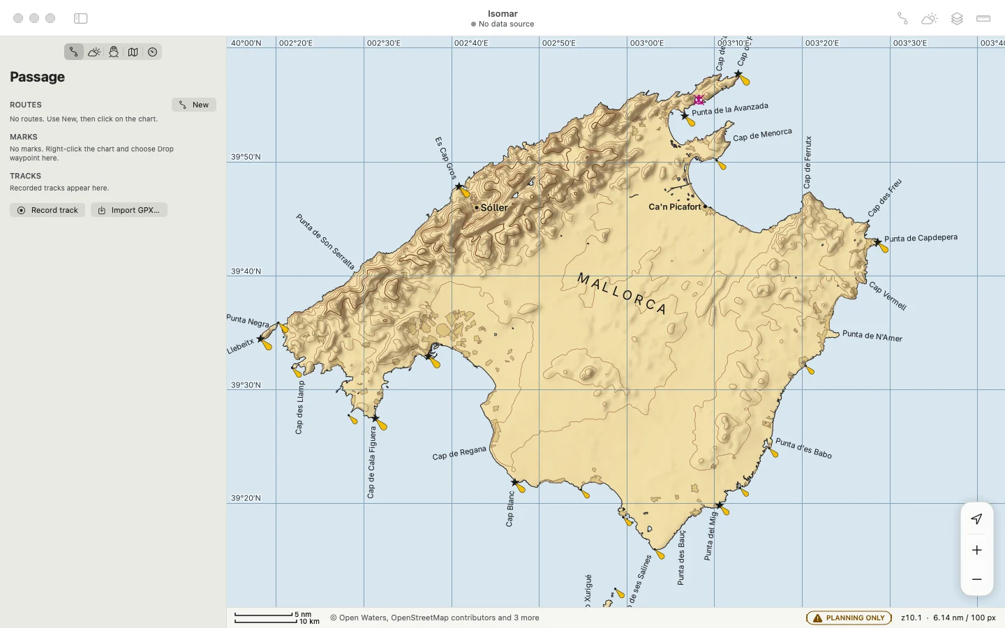
Mallorca on macOS: capes named out from their tips, the island's name in capitals, the Balearic Sea lettered across the water.
Mallorca, on macOS: capes named off their tips, the sea lettered across the water.

Weather

Faster forecasts download on slow or expensive connections

GRIB downloads are huge, slow and confusing: which model, which area, which fields, and how big will it be on a phone hotspot?

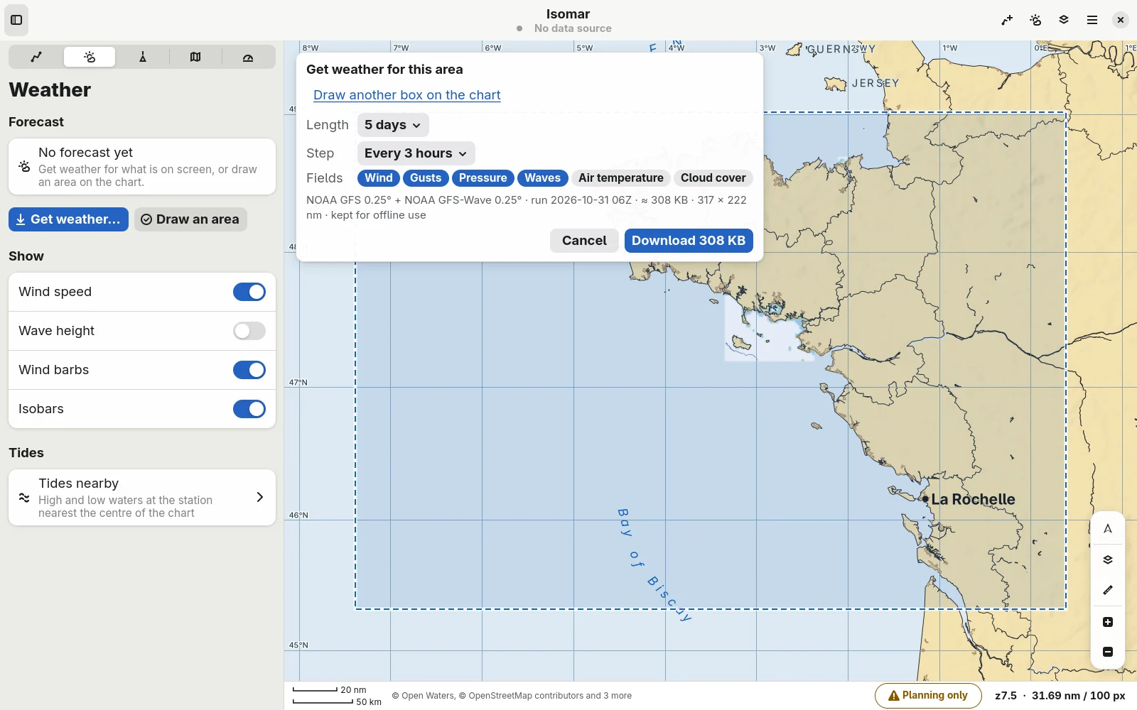
Right-click the chart and choose Get weather here, for this view or for an area. Isomar asks NOAA's GFS for just that box and just the fields you tick, and tells you the size before it starts.

  • Wind, gusts, pressure and waves as colours, barbs and labelled isobars over the chart.
  • A timeline to play the forecast forward, hour by hour.
  • Kept for offline use, with a warning when the forecast is getting old.
  • Tides at the nearest station, with the curve for the day.
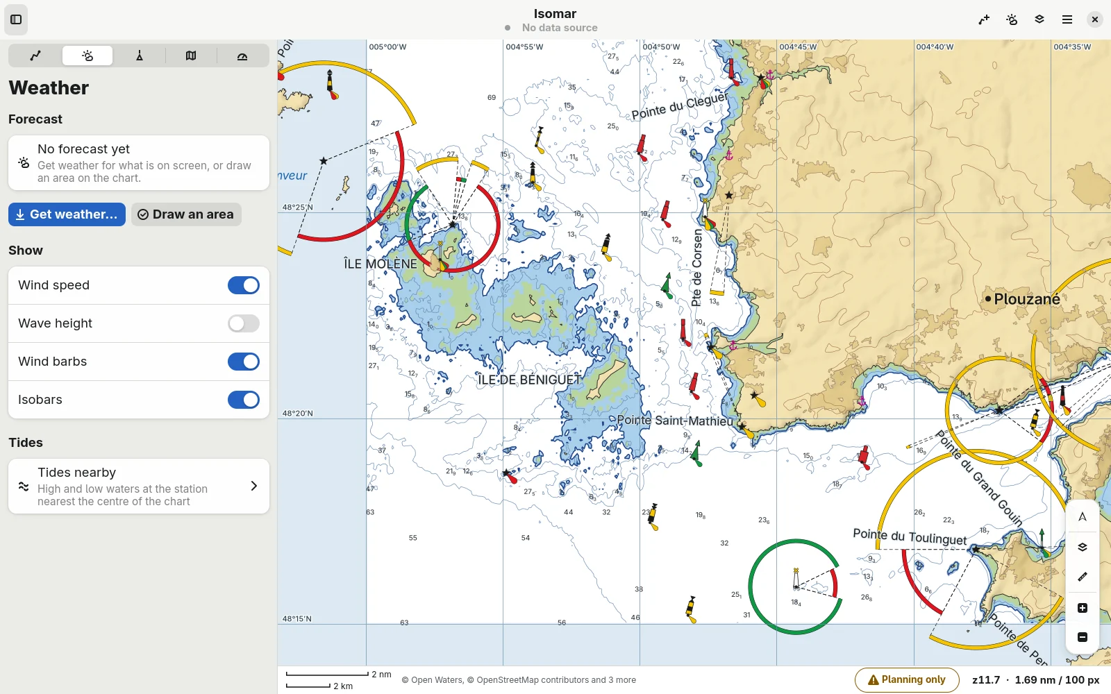
The Get weather card on Linux: forecast length, time step and fields, with a download size of 308 KB.
Five days of wind, gusts, pressure and waves for South Brittany: 308 KB.

Weather routing

Know when to leave, not just which way.

A weather router draws you one line for one departure time. Whether leaving tomorrow or on Tuesday is kinder or faster is left to you.

Isomar routes your passage with the forecast, your boat's polar and the coastline. Then Best time tries every departure in a window and ranks them.

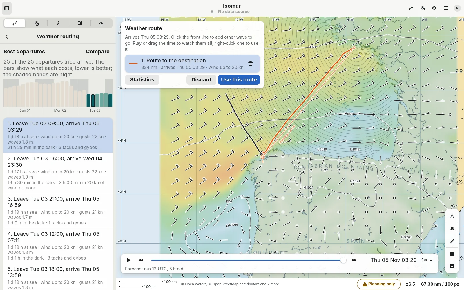
  • Ranked departures: time at sea plus the hours upwind, under engine, in strong wind, gusts, rough sea and dark, each weighted as you like.
  • Alternatives: click the front to compare other ways to go, and play them all along the timeline.
  • Engine in light wind, wind limits, and your own polar.
  • The plan is kept with the route, so you can replay it later without the forecast files.
Best departure on Linux for Lorient to A Coruña: a bar chart of the cost of each departure over three days, the best ones listed, and the best route's isochrones over the wind forecast.
Best departure from Lorient to A Coruña: 25 departures tried, the best one previewed with its isochrones.

Under way

Calm when it matters.

At night, in traffic, a plotter that beeps at everything, hides the depth in a corner and blinds you with a white screen is worse than none.

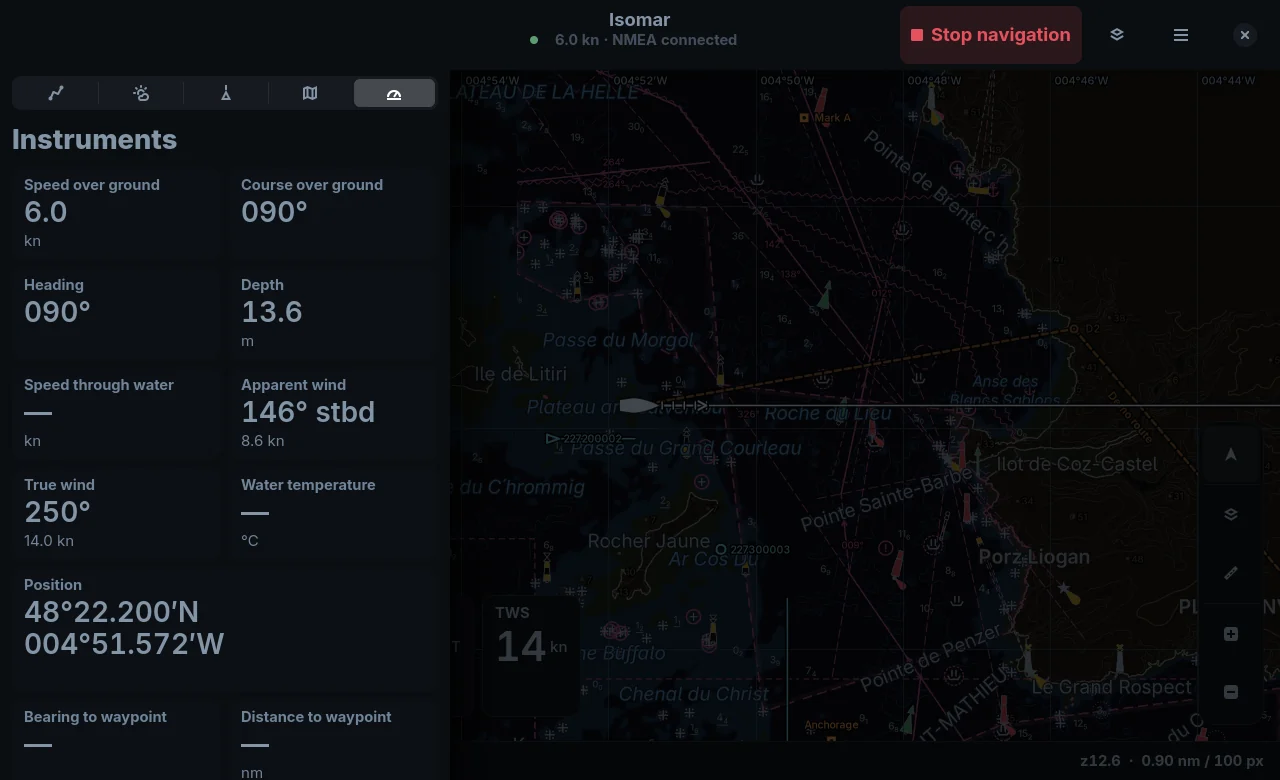
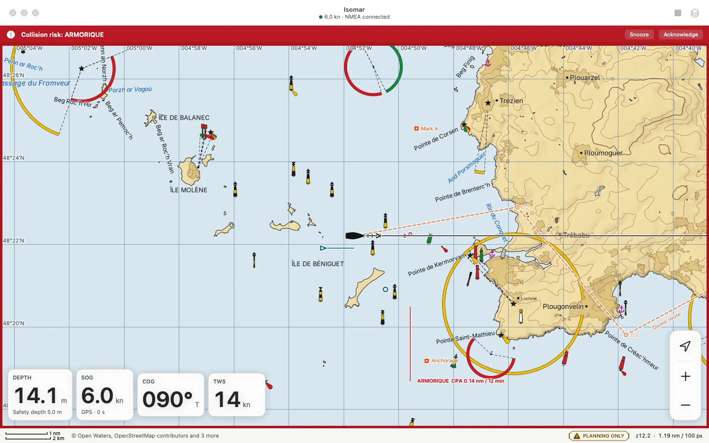
Isomar switches to an under-way layout with big, readable instruments, and its alerts are ranked: a collision risk takes over the screen, a stale forecast doesn't. Alerts don't fire again for the same ship.

  • NMEA 0183 over TCP, UDP or serial, gpsd and Signal K, with a data monitor.
  • AIS with CPA and TCPA collision alerts you can snooze or acknowledge.
  • Anchor watch, active route with cross-track error and ETA, track recording.
Isomar under way at night on Linux: the instruments page with speed, course, depth and wind, the chart in the night palette.
Night palette, under way, with the instruments beside the chart.
Under way on macOS: a collision risk alert for the ferry Armorique, with depth, speed, course and wind on the dashboard.
Under way on macOS: a collision alert, the ship's closest approach on the chart, and the dashboard.

Your charts, your data

No subscription. No lock-in.

Chart apps that only open their own encrypted charts, on one device, for as long as you keep paying.

Isomar reads the charts you have licensed in open formats, and knows where the free ones are. The Charts page lists the free sources for the area on screen, rated for quality, and installs them in one click.

  • Free official charts where they exist, such as NOAA's for all US waters.
  • Your own folders of S-57 cells and KAP rasters.
  • GPX import and export compatible with many devices and software.
  • Everything stays on your computer: no account, no tracking.
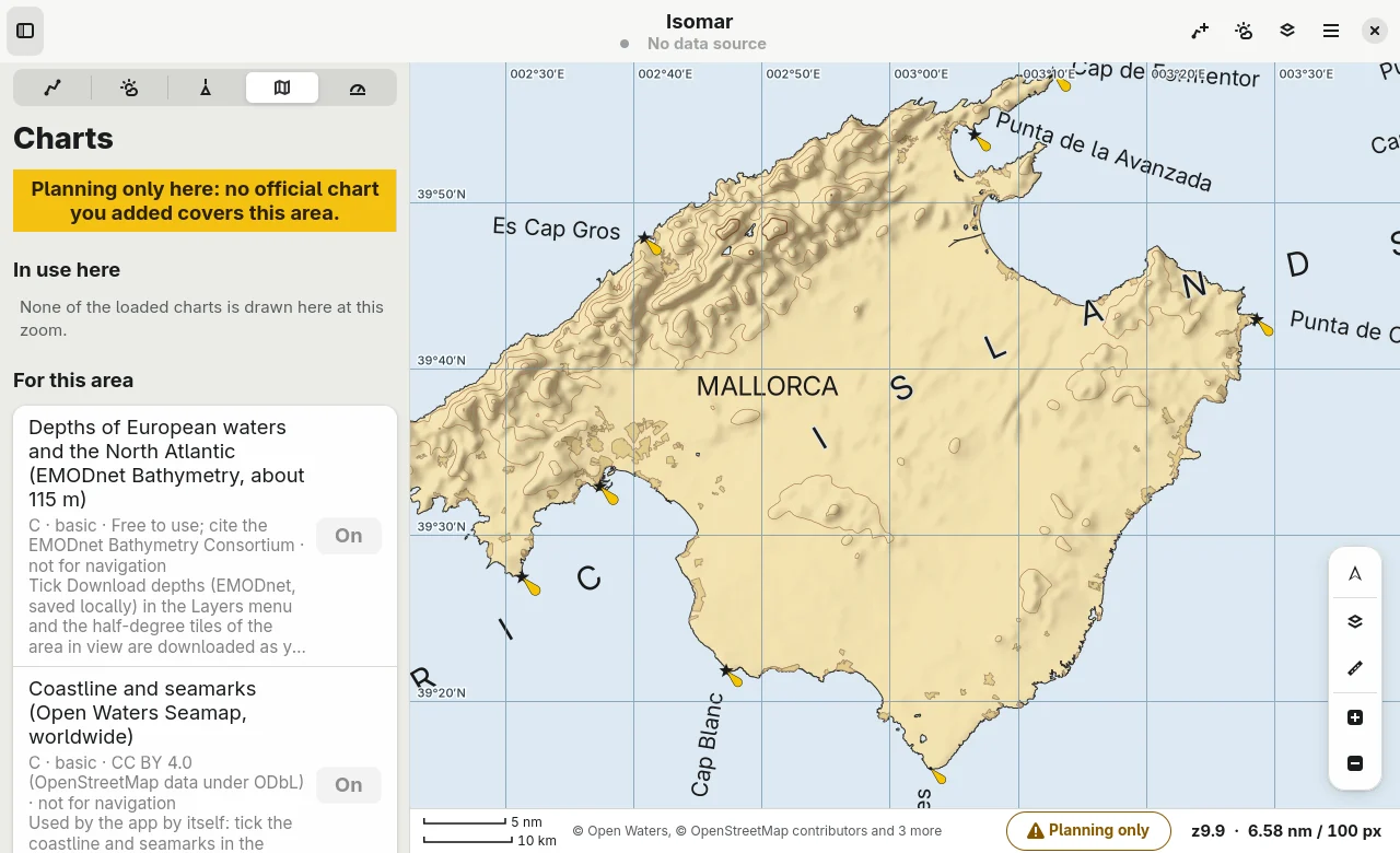
The Charts page on Linux listing free chart sources for the area on screen, each with its quality rating and licence.
The Charts page: what is installed here, and the free sources for this area.

Download

Free, for Linux and macOS.

Version 0.3.0, released 29 October 2026. Isomar is free software under the GPL-3.0 licence.

Your system

Linux

Flatpak bundle (6.1 MB)

  • Any distribution with Flatpak (Fedora, Ubuntu, Debian, Arch…)
  • Uses the GNOME 50 runtime from Flathub
flatpak install --user Isomar-0.3.0.flatpak
Your system

macOS

Disk image, Universal (33 MB)

  • macOS 13 Ventura or later
  • Apple silicon and Intel Macs
  • Signed by Apple: open the disk image and drag Isomar to Applications

Planning only, not for navigation!Isomar is early software. The free chart it womes with is built from open data and is not an official chart, and forecasts are models. Use it to plan but navigate with official charts and your own judgement.